Car Walk, Sands 9.00am
Carlisle & District Rambling & Fellwalking Club
This Weeks Walks
This Weeks Walks
Sunday 21st September 2014
B Walk
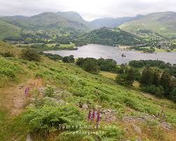
Round Place Fell from Boredale
8 Miles Grade 2/3
Leader: Alan Dobson
Car Walk, Sands 9.00am
Sunday 21st Sept 2014
Car Walk, Sands 9.00am
It would be very much appreciated if all walk leaders submitted a description of their walk. Preferably by the Monday preceding the walk. Descriptions can be emailed to
ramblingclubjohn@aol.com or telephone: 530306


We meet at Kilngreen car park , Langholm, where there are toilets, before driving in convoy to the village of Bentpath. There we turn left over the bridge following a single track road along the side of the Meggat Water to Glendinning where Thomas Telford was born in 1757. There are information boards near the small car park.
The B walk follows the track past the former antimony mine and then follows tracks round and up Glenshanna Knowes, with tremendous views of the hills to the west and south, before descending the hill to Corlaw. The B walk now follows the C walk back to Glendinning.
The C walk begins by crossing the river by the ford or a rickety bridge to follow the track to Corlaw. Then we follow a felled forest track to Greensykes, a former shepherd's cottage now renovated as a bothy by the MBA. Then we follow the track beside the Meggat Water with lovely views and with only sheep as companions back to the car park.
Sadly there are no tea shops so we just have to return to Langholm and seek refreshments there.
Nancy
Sunday 21st September 2014
A Walk
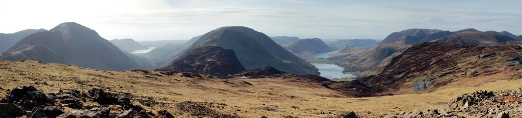
Grey Mare's Tail
8 Miles Grade 1
Leader: John McKay
Map OS Explorer 330
Start/Finish GR 186145
Click on the map to enlarge
We’re off to Scotland again for this walk, Moffat & the Rumblin Tum on the agenda. Possibly an independent Scotland as the vote will have taken place only three days before. I doubt they will have had time to set up border posts, if it was a yes vote, but you never know, bring your passport just in case. We set off from the car park at Tailburn Bridge on the A708 about 10 miles from Moffat. It’s quite a steep start as we follow the path alongside Tail Burn, which takes us up to the waterfall (Grey Mare’s Tail ) It levels out for quite a bit and we eventually round a bend to be greeted by the sight of the lovely Loch Skeen. We can have a short coffee break and admire the view before continuing. We head over to the right towards the fence. This is a short section and can be quite muddy, in fact it will be muddy, it's always muddy, even if there’s been no rain for weeks. We start climbing again keeping the fence on our right. You should never get lost on this walk, you just follow the fence all the way round. We reach Lochcraig Head which will probably be our lunch stop. The climbing for the day is just about over but there is a short steep section to come later. We follow the fence all the way round to White Coomb, the high point of the day at 821 metres. (2693ft). Weather permitting the views are fantastic, weather not permitting you will be lucky to see your feet. We head off from White Coomb down a fairly steep descent till we reach Tail Burn again. This could be the only problem of the day, it can be difficult to cross at the best of times and if it’s in full flow it can be very difficult to cross but don’t worry, I always have a cunning plan up my sleeve. Once across the burn we rejoin the path which takes us back to the car park. Hopefully we will make it back to Moffat before the Rumblin Tum closes. A classic walk, if you have never done it before don’t miss it. Even if you have done it before don’t miss it.
John
We travel by car to Patterdale , there is limited free parking here and it will depend on how busy it is if there is any available
Walking through the village we cross the beck ( bridge) and head upto Bordale House and then pickup the path which snakes up the hillside, keeping to the path we come to a chimney and bear left continuing a steady climb, Place Fell is one of those fells. where you think you at the summit only to find there is another part to climb however the views can be spectacular on a clear day over to Helvellyn, up Ullswater and to the east over High Street ,. we reach the summit of 657metres.
From the summit the path follows the tops to a sheepfold and then splits into two to the right it descends quite steeply to Garh Head and then we follow the lowland path back around Ullswater past Howetown and Silver bay back to Patterdale total distance approx. 8 miles
Alan


